Hiking to Hermannsdalen

Difficulté 3
Moskenesøya
3 to 5 hrs
13.9 km
1200 m
540 m
Vest-Lofoten - 1:50 000
Until May on the top
Type de rando :
Go back
Visibilité du sentier :
Moyenne
Départ/Arrivée :
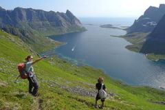
400m after Vinstad landing quay, on the way to Bunesfjorden. The start of the trail (not obvious) is located just after a white farm house in a meadow.
Point(s) GPS :
Start/Finish : N67 57.658 E12 59.995 Summit of Hatinden : N67 57.530 E12 58.325 
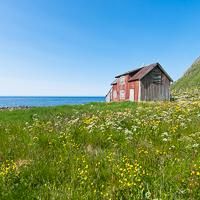
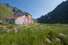
Old farmhouse near the beach : N67 57.579 E12 54.915

Description


This magnificent hike takes you to the lost Hermannsdalen Valley. At the end of the valley, facing the ocean, there is an old abandoned farm, a sign of times not so long ago when people still lived in this extremely isolated part of the islands. This is one of the few hikes that takes you to the virtually inaccessible west coast of the island of Moskenesøya. Hermannsdalen is the perfect place in which to set up camp in a magnificent, peaceful landscape only 4 hours’ walk from Vindstad…


More information about this hike...

Cover EN ptYou can read the detailed description of this hike (as well as 59 other hike descriptions), enjoy hundreds of photos, maps and practical information on the paper guidebook Hiking the LOFOTEN ISLANDS.
You'll find the guidebook on logo amazon en, as well as at the following bookstores, for 24,07£ (not including shipping).

Order on Amazon

Accessibilité

Accessible to dogs

Diaporama