Hiking to Kartstaven

Difficulté 2
Vestvågøya
3 to 5 hrs
9.9 km
550 m
534 m
Vest-Lofoten - 1:50 000
Until May on the summit
Type de rando :
Go back, Loop
Visibilité du sentier :
Bonne, Moyenne
Départ/Arrivée :
If you are coming from Leknes head northwards (towards Svolvaer). Leave the E10 9km after Leknes, approximately 700m after the large Lake Sjerpvatnet that runs along the right-hand side of the road, and take the road to your right. Carry straight on for 1.7 km before turning left at Nykmarka where there are a few isolated houses and a small farm. The path begins alongside the farm and takes a tractor route that descends towards a few fields.
Point(s) GPS :
Start/Finish: N68° 12.308' E13° 43.678' 
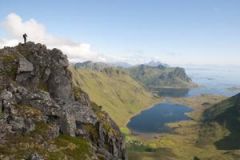
Summit of Karstaven: N68° 11.637' E13° 47.870' Peat hut: N68° 11.183' E13° 45.430'

Description

The top of Kartstaven, which is only 544m altitude, is in the centre of the island of Vestvagoya and offers a direct view over Vestfjord, which extends from the narrow Kartfjord. This hike is relatively easy and the trail is clearly marked if you choose to make a return trip.


More information about this hike...

Cover EN ptYou can read the detailed description of this hike (as well as 59 other hike descriptions), enjoy hundreds of photos, maps and practical information on the paper guidebook Hiking the LOFOTEN ISLANDS.
You'll find the guidebook on logo amazon en, as well as at the following bookstores, for 24,07£ (not including shipping).

Order on Amazon

Accessibilité

Accessible to dogs, Snowshoe

Diaporama