Hiking to Moltinden (Flak)

Difficulté 4
Flakstadøya
3 to 5 hrs
4.3 km
700 m
681 m
Vest-Lofoten - 1:50 000
Until May on the summit
Type de rando :
Go back
Visibilité du sentier :
Moyenne, Mauvaise
Départ/Arrivée :
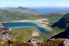
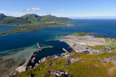
Park in the centre of the village of Ramberg in the "Bunnpris" supermarket car park. Take the path opposite the cark park. This leads to the big round reservoir you can see from the car park. The track starts from the other side of the reservoir.
Point(s) GPS :
Start/finish: N68 05.370 E13 13.745 Summit: N68 05.288 E13 15.570

Description

 
This short, strenuous hike takes you from sea-level to an altitude of 700 m in approximately 2 km. The route is steep! The view from the top is extraordinary because it gives onto both the Norwegian Sea and the mountain peaks to the south of the islands.


More information about this hike...

Cover EN ptYou can read the detailed description of this hike (as well as 59 other hike descriptions), enjoy hundreds of photos, maps and practical information on the paper guidebook Hiking the LOFOTEN ISLANDS.
You'll find the guidebook on logo amazon en, as well as at the following bookstores, for 24,07£ (not including shipping).

Order on Amazon

Accessibilité

Not defined

Diaporama