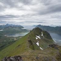
Hiking to Svarttinden

Difficulté 2
Austvågøya
2 to 3 hrs
6.6 km
770 m
713 m
Vågan - 1:50 000
Until May on the top
Type de rando :
Go back
Visibilité du sentier :
Bonne
Départ/Arrivée :
The trail start in the middle of the hamlet of Gravermarka
Point(s) GPS :
Start : N68° 18.045' E14° 19.086' Summit : N68° 18.126' E14° 21.719'

Description


This mountain, which overlooks the tiny hamlet of Gravermarka can be accessed on a good trail which, for once, does not disappear during the hike. After a section through undergrowth you rapidly reach grazing land that offers a clear view over an amphitheatre-like rock formation and a lake. In the last part of the climb, the very beautiful open view is perfect for admiring the highest mountains on the islands. The rocky landscape of the summit is similar to that of high mountain ranges with small lakes and snow patches that remain until late in the season. A good hike, not particularly demanding, accessible any yet very few visitors, only 30 min from Svolvær.


More information about this hike...

Cover EN ptYou can read the detailed description of this hike (as well as 59 other hike descriptions), enjoy hundreds of photos, maps and practical information on the paper guidebook Hiking the LOFOTEN ISLANDS.
You'll find the guidebook on logo amazon en, as well as at the following bookstores, for 24,07£ (not including shipping).

Order on Amazon

Accessibilité

Accessible to dogs, Family friendly, Snowshoe

Diaporama