This slender peak faces the summit of Tjeldbergtinden. It is higher than Tjeldbergtinden and gives you a remarkable panorama over the town of Svolvær and the northern part of Vågan Island. You make the ascent on a good trail over a straight ridge line—sometimes dizzying, but not dangerous when the ground is dry.
More information about this hike...
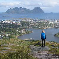
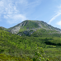
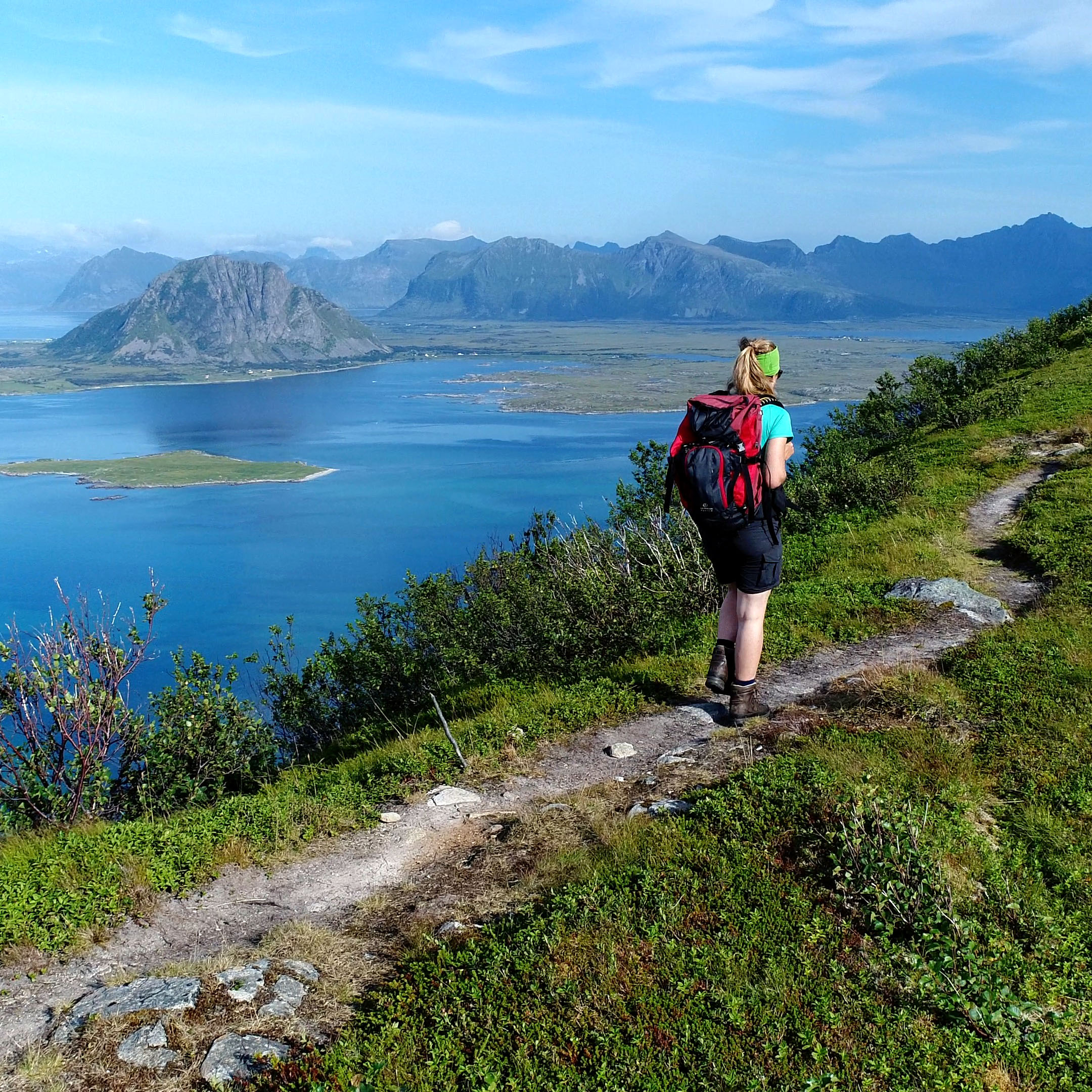
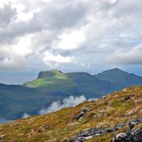
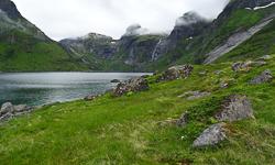
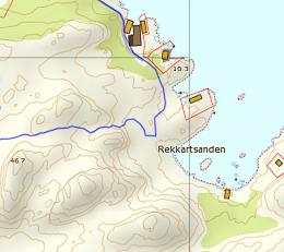
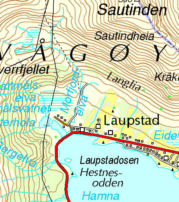
The summit of Sautinden—literally the “sheep summit”—actually has pastures that sheep love. It is very easy to reach. Sautinden is at the northern limit of the Lofoten Archipelago and gives you a magnificent panorama over the Austnes fjord as well as the two highest peaks of the Lofotens. Finally, the trail leading to the top can take you to other summits like Kvittinden and Kåpa, but also to the hamlet of Morfjorden on the north coast of the islands.
More information about this hike...
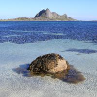
This rarely visited peak is located at the southern tip of the little island of Gimsøya. The absence of a trail, the rich vegetation and the steepness of the slope make it complicated to reach the summit, but the view really deserves a little effort.
Coming from Leknes, go about thirty meters (yards) further than the Jørndalen farm (so as to avoid bothering the people who live there by encroaching on their property) and cross the ditch to the left of the road. Make your way to the edge of the woods to go around the farm by the right and walk to the stream flowing at the bottom of the valley of Jørndalen.
You’ll find a vague path that goes a few hundred yards along the stream. It then disappears into a steeper slope, covered with dwarf plants. In this part of the ascent, there isn’t really a trail and you’ll have to make your way by avoiding areas where the plants are too thick and the passages too steep—until you reach the altitude of roughly 250 m (820 ft).
Around this altitude, roughly at the spot where the markings of the stream disappear from the 1: 50,000 map, the little valley grows wider and the slopes less steep, replaced by a sort of cirque whose central part reaches a pass. Again you’ll find vague paths made by passing sheep. Follow these paths toward the pass between the summits of Sundklakktinden and Svarttinden.
Once you're at the pass, take a left and follow the east ridge of Sundklakktinden on an easily visible trail. It is possible to climb directly up to the summit or—this is what the line marked here shows—you can walk to the southern part of the mountain to have a lovely view, looking down over the straits and the village of Henningsvær.
Once you’ve reached the summit of Sundklakktinden, it’s easy to reach the summit of Skjolden to the north. It’s about sixty-five feet higher and gives you a unique panorama over Gimsøya Island and the northern coast of the archipelago.
Back the same way.
The variety of natural landscapes in a limited space where you can sense the ancient presence of man gives Skrova the atmosphere of a miniature world. You can observe it as long as you like from the top of Høgskrova. We’ve already seen that the local community takes particular care to mark and maintain the different trails in the most isolated places. Thus you’ll find several itineraries with colored dots showing you the way, as well as a panel summarizing the hike at the start of the main path.
More information about this hike...
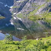
This short, easy hike takes you over a little trail to one of the hidden jewels of Moskenes Island: Svartvatnet Lake.
This beautiful dark lake overlooks the natural reservoir of Solbjørnvatnet, nestled in its green setting. The sharp peaks that surround it give this site a majestic look.
You can rapidly—and almost effortlessly—reach these impressive landscapes where nature is still intact, in the heart of Moskenes Island.
To the right of the dirt road, you’ll find a little trail (hardly visible at first) that rises toward the pass between the summits of Fjøsdalstinden and Okstinden. The trail starts to the right of the little valley and then goes into its center and crosses the stream. The trail continues on the left of the stream before reaching the pass.
A beautiful panorama is awaiting you at the pass, with the Vestfjord to the east and the big lake of Solbjørnvaten to the west.
Next, follow the trail the left-hand trail. It goes over a wide natural balcony around 180 high (590 ft) and then reaches Svartvatnet Lake, curled inside a mountain cirque. On the way, the trail passes near small bodies of water bordered with droseras (carnivorous plants).
When you reach the lakeshore, keep going for a bit on the trail along the right bank of the lake until you reach its outlet (N67° 59.327’ E13° 08.338’).
The outlet takes the form of a pretty mountain stream. The amount of water in it varies according to the season.
The edge of the lake is an invitation to relax, for the place is so calm and wild. The dark waters of the lake are surrounded by a delicate crown of rich vegetation against a background of sharp, austere mountain peaks that give you the impression of a landscape straight out of a fairy tale.
Possible alternative
From the pass, it is possible to reach the summit of Okstinden (263 m / 863 ft). It’s easy to get to this pass and it gives you a fine panorama over the hamlets of Sund and Mølnarodden. Take the trail to your right (toward the north), following the ridge. After the first little nameless summit whose high point is roughly 270 m (886 ft), the trail disappears. Despite the absence of a trail, the way to the Okstinden summit is relatively obvious.
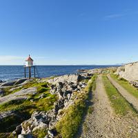
Anyone can walk this hike along the coast in a part of the big island of Austvågøya that is still largely unknown. You leave from the hamlet of Brenna and walk along the northern coast of the island on a good path that serves a few isolated houses facing the Norwegian Sea. The path ends in the tiny hamlet of Nedreneset, at the entrance to the Indrefjorden.
The trail starts after the fence at the northernmost part of the hamlet and goes toward the coast. You quickly reach a little lighthouse (to your left) and keep going to the cape of Festvåg. You’ll see several farmhouses along the trail, now converted to summer homes. The trail follows the coast, sometimes through the underbrush, sometimes through little pastures until the hamlet of Nedreneset.
It is possible to continue to the end of the valley on a trail that goes along the right bank of the Indrefjorden, but in summer, high grass hides the ground, which is often wet.
Go back the same way.
If you're in Sørvågen and don’t have the time or energy to climb one of the iconic summits of Moskenes Island, here’s a short hike that will take you to the shore of the mysterious lake of Trolldalsvatnet (lake of the valley of the Troll). The rest of that mass of water surges into the bottom of narrow valley surrounded by impressive cliffs. The access trail goes through a natural landscape worthy of Scandinavian tales, as it runs alongside of lakes, misty undergrowth and tumultuous waterfalls. The combination is enough to amply justify the name that was given to this place.
Behind the village of Sørvågen, take the trail that goes over a rocky mound, under the electric line, toward the little valley that goes up to Stuvdalsvatnet Lake. At the foot of the valley, just after you cross the stream on a little bridge, take the left-hand trail that goes up the hill over the waterfalls to the outlet of Stuvdalsvatnet Lake. Cross the outlet of the lake by going over a second bridge and take the trail to the right after the bridge (the left-hand trail goes to the Tindstinden summit). The trail follows the lakeshore for about 500 yards. Some banked passages may be slippery if it’s raining and in some places the locals have installed bits of rope to help you get across them. Toward point N67° 53.811' E12° 59.601', the trail leaves the shore of Lake Stuvdalsvatnet and goes up a little valley oriented east-west. The trail goes over a stream, then joins the body of water connecting Lake Trolldalsvatnet to Lake Stuvdalsvatnet. Next, the trail follows the left bank of that body of water to the lake. There, you’ll see three or four tiny cabins (boat shelters). A gangplank enables you to reach the right bank of the lake. You can walk along the bank for roughly a hundred yards more. Take the same trail back.
This summit on Vestvågøya Island is rarely visited, but it has magnificent panoramas in store for anyone bold enough to climb it. No crush of hikers here in any season: only a tiny passage through thick, rich vegetation that will bring you to a high mountain pasture on a plateau—the last walk before the summit. The points of view are many and varied all along this wild and sometimes difficult itinerary. We’ve described it as a round trip but it is also possible to make a great loop around Lake Lyngedalsheia.
To get to the tiny trail that climbs the west slope of Lyngedalsheia through the forest, you’ll first have to reach the old farm at the end of the path that goes along the east bank of the lake. You can either reach this path by walking along E10 for a hundred yards or so, or by going along the northern tip of Lyngedalsvatnet Lake. To do the latter, you’ll have to cross the stream that flows from the lake by going over some rocks. At the end of the path, you come upon an old farmhouse. A very small trail starts behind it, cut into the woods and marked out from time to time by red plastic posts. You’ll have pay very close attention to follow these discreet markings without losing them, especially when the vegetation is high. After a rather steep climb up the undergrowth, you reach the Lyngedalsheia plateau, a vast bog covered by very low plants. From the plateau, you’ll have your first point of view over the north and Gimsøya Island. Cross the plateau to reach its eastern side. From there, you can walk due south toward the northwest ridge of the Håtinden summit. There is no real trail but you can see a few signs of passage (mostly sheep) on the eastern border of the plateau as well as on the ridge leading to the peak. A small passage lets you climb the ridge to the summit. Avoid the scree and other fallen stones covering the slopes of the mountain as much as possible, but sometimes you’ll have to use your hands to get through the rocky passages.
The summit gives you a fantastic panorama, particularly out toward Austvågøya Island and the wide arm of the sea that separates it from the island of Vestvågøya. From the summit, you can keep going toward the southeast and reach the southern ridge of the mountain in the direction of Litlhåtinden up to a small pass at an altitude of 450m (1,476 ft). The passage between the Håtinden summit and the pass gives you a series of fabulous, varied landscapes.
Go back the same way. Even if it seems tempting, it is a very bad idea to go down into the little valley to the right of the pass to reach Lake Lyngedalsvatnet: if you opt for this “solution”, the tree-covered part of the valley and the return by the right bank of the lake are totally off trail and you’ll spend much more time and energy than if you returned by the summit.
From the pass, it is possible to keep going toward Vikjorden, and then, in passing by Kitaksla (532 m / 1,745 ft), to reach the southern tip of Lake Lyngedalsvatnet. To do this, you have to go around the Vikjordtinden summit by the south, at an altitude of roughly 500 m (1,640 ft) and then take the passage by the Kitaksla ridge and reach the little trail toward Finnvollen one way or another. From there, after you cross a vast boggy plain, you can get to the left (west) bank of Lake Lyngedalsvatnet and walk back to your starting point.
Watch out! This latter option is really difficult: it has passages that are precipitous and others that are steeply banked. What’s more, you won’t find a trail there worthy of the name.
There’s a little trail that takes you from the electric power station of Forsfjord to the hamlet of Vindstad. This itinerary lets you avoid the very undependable ferry service that connected the two points (only on demand) until last year.
The trail is barely visible but won’t give you any major problems. It goes through two passages of big stone blocks and passes over a few rocky slabs where you’ll have to be careful, especially if you’re carrying a heavy pack. Finally, like many places in the Lofotens, the ground is partially covered by thick vegetation (ferns).
This mountain with its cut-off peak looks down on the bay of Skokkevika, its turquoise waters dotted with countless little islands. This is one of the most spectacular parts of Vestvågøya Island and even in all the Lofotens. It’s easy to get to the starting point of the hike along Route 815, it has superb viewpoints and a fairly easy trail to follow, yet few hikers come to this place.
This summit overlooking the fjord of Skifiorden near Stamsund is still hardly known by hikers. There is no trail to reach it and the slopes are extremely steep. Despite these difficulties—surmountable for a hiker used to navigating this kind of terrain—the panoramas are impressive and varied all along the way.
The Kroktinden summit, “the crooked summit” in Norwegian, looks like the tooth of a saw pointing to the sky. It’s a beautiful peak, relatively easy to reach, and offers a series of fantastic panoramas over the most mountainous island in the archipelago. Finally, not to diminish your pleasure in the slightest, a pretty little trail is visible all along the way and goes right to the summit.
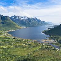
Few hikers come here, although the summit is relatively easy to reach and looks down over the magnificent fjord of Austnes. You can admire varied landscapes of high pastures, lakes and mountains all along the way. If you want to walk far from crowds of tourists, while looking at one of the most beautiful summits Austvågøya Island, don’t miss this magnificent hike.
This summit, in the north of Vestvågøya Island, lets you discover a relatively unknown part of the archipelago. Three quarters of the ascent goes up a magnificent ridge line that gives this hike a very aerial look. Finally, the exceptional location of this summit gives it a unique panorama: it’s at the tip of a peninsula, facing the Norwegian Sea and with two big arms of the sea around it.
At the northwest tip of Vestvågøya Island, in a part of the archipelago that is still rarely visited, the discreet summit of Hellostinden holds pride of place. The walk to the top goes over relatively easy terrain through open landscapes. The panorama is magnificent from the summit, particularly the view of the Vågakallen massif on the neighboring island of Austvågøya. A hike for the whole family.
More information about this hike...
 You can read the detailed description of this hike (as well as 59 other hike descriptions), enjoy hundreds of photos, maps and practical information on the paper guidebook Hiking the LOFOTEN ISLANDS.
You'll find the guidebook on  , as well as at the following bookstores, for 24,07£ (not including shipping).
Order on Amazon
This hike is a real adventure that has lots of surprises for you! After a grueling start through rich vegetation on extremely steep slopes, you reach a peaceful valley with a succession of lakes and pastures, where half-wild sheep graze in season. The fine path you’ll find in the upper part of the valley was once used to construct a series of little dams and underground catchment areas that feed the electric power plant down below. Finally, despite the name Baken (which usually means a rounded hill in Norwegian), the summit is a real peak that gives you a striking view over this little-known part of the Lofotens.
More information about this hike...
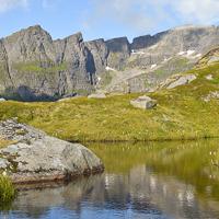
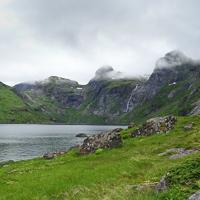
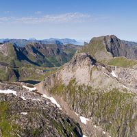
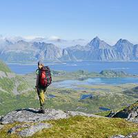
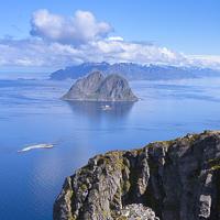
Sautinden and Bjørntinden
Pictures and track proposed by Halfdan Holm
These two peaks aren't among the most climbed in Lofoten, rather the contrary. No obvious path emerges from below, but climbing them is indeed possible, however only for experienced hikers.
The first leg of the trip follows a steep slope up 600m. One will then have to cross a somewhat steep and ravinated passage before getting up to the plateau with a beautiful view down to Flakstadpollen. The last leg up to Sautinden is a relatively easy hike. Getting from the plateau to Bjørntinden requires walking on some grassy slopes, where you wouldn’t want to slip. The last leg up to Bjørntinden is quite steep, and requires climbing with hands a couple of places. At the top you get a great view of the majestic Stjerntinden, the highest mountain on the Flakstadøy. You go back the same way, however getting directly down to Skjellfjorden from Bjørntinden may be possible, we don't know as there was zero visibility during our trip.
Pictures and track proposed by Halfdan Holm
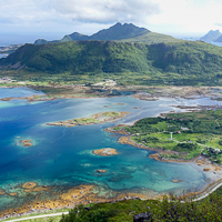
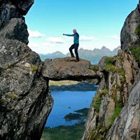
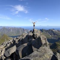
This short, but somewhat intense hike takes you from Svolvær and straight up to an altitude of almost 600 m in about two hours. On the trip you get a great view of the famous Svolværgeita, a stop by the picture-worthy Djevelporten and then a fabulous view of East Lofoten from the top of Fløya. Though be advised: the very final part up to Fløya is only for experienced hikers, however the view a couple of meters further down is just as spectacular!
The first leg follows a clear path up a very steep hill. The walk is fun and a bit challenging, extra caution is required in wet weather. The path then flattens out and suddenly the challenge is mud rather than the steep climb. After passing Djevelporten the path follows the ridge towards the top of Fløya. At some points the path is somewhat unnecessarily close to the cliff, so walking a meter or two parallel to the path can be recommended here and there.
If you'd prefer not to climb up to the very top of Fløya, there's a path going southwest directly to a lower viewpoint, about 40 meters below the peak. If you decide to go all the way to the top you will be forced to climb using our hands in close proximity to the cliff. Climbing down the western ridge from Fløya is also a challenge, so going down to the other viewpoint via the northern ridge may be recommended.
This long hike lets you get to the old village of Måstad in southeastern Værøy by traversing a large part of the island. It’s also the only way to get to the summits of Måhornet and Måstadheia, with their fantastic viewpoints over the open sea and their unique end-of-the-world atmosphere. The whole Måstad peninsula is classed as a natural park.
More information about this hike...
The summit of Håheia (438 m). is the second highest peak on the island of Værøy. It is also the only peak in the archipelago that has a road. It is private and leads to a NATO radar installation. Outside of this little bit of civilization, the wide open landscapes you’ll go through are magnificent. If the weather is clear at the top, you can admire the southeast of the Svartisen glacier, which is 120 km (75 mi). away on the Norwegian continent. This hike is easy and accessible to all. If you have time, you can extend it a little, to the summit of Hornet.
More information about this hike...
")