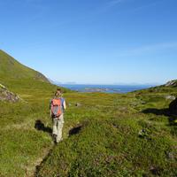
This good 17 km hike takes you from the bay of Malnesvika as far as the fjord of Rolvsfjorden. The route passes through mountain and valley landscapes where the only living things are a few sheep. The more rounded mountains, unspoilt valleys and plateaus covered with peatland make this little-known and still rarely visited part of the island of Vestvågøya worth the detour.
More information about this hike...
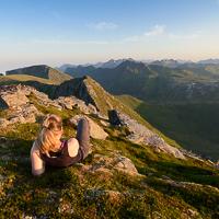
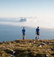
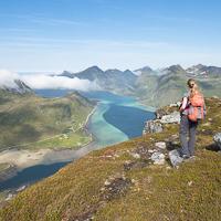
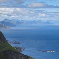
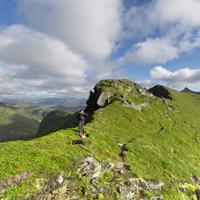
This impressive peak overlooks the tiny hamlet of Vikjorden. Looking up at it, the peak looks completely inaccessible, but there is in fact a very safe path to the top from where the view is absolutely fabulous!
More information about this hike...
A good hike that will take you, ridge after ridge, through the open, maritime landscapes of this part of the large island of Vestvågøya. On the way back you walk through an unspoilt valley the length of three mountain lakes where the only noise is the occasional trout jumping…
More information about this hike...
For once in the Lofoten Islands this route is clearly marked from the beginning up to the peak without any particularly demanding sections. This hike is possible for entire families and despite the fact that it is not particularly high, there are magnificent views along the entire route.
More information about this hike...
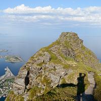
This hike, which offers no particular challenges, quickly takes you onto a magnificent path along a ridge from where you can see the most beautiful part of the eastern coast of the Lofoten Islands with its many coves of fine sand, its clusters of islands and islets and its crystal-clear waters.
More information about this hike...
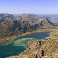
Varden (Norwegian for “Cairn”) is a magnificent peak that is easily reached and overlooks the narrow stretch of sea separating the islands of Vestvågøya and Vagan. Our route takes us near several little lakes that tempt you to have a swim in summer and soon continues along a curved ridge that offers a magnificent panorama over the Sea of Norway and the northern tip of the Lofoten Islands.
More information about this hike...
Hiking to Stortinden
Route proposed by Halfdan Holm
This trip takes you to the second highest peak of Flakstadøya, but it is the highest reachable for an average hiker. It is not an easy trip though. There are practically no path, and it is a steep climb all the way, with one specific point which might make someone feel a little bit uncomfortable.
You park your car at the old high school (N68° 04.689' E13° 14.274'), and walk by the road to where the GPX-track starts. Here you’ll walk on the trips only path for some hundred meters. Then you’ll walk in a steep grass slope to the place where you’ll want to use your hands to help yourself up the mountain.(N68° 04.478' E13° 15.668' - just a meter or two). Shouldn’t be too difficult, but some experience is recommended. Then you’ll continue quite steep up to the pass, where you start walking at the east side of the mountain, before you swap over to the west side the last hundred meters to the top.
The summit is located close to an incredibly steep drop in the north, but there is no need to pass any too steep drops during the trip itself. Not recommended for people who are too afraid of heights though.
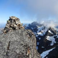
When you’ve made it to the top you’ll be rewarded with some of the best views in the entire Lofoten.
Same way back.
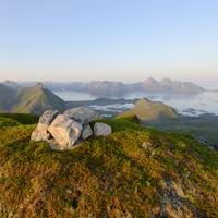
Geitgallien is the second highest peak in the Lofoten islands after Higravtindan which is only 61 m higher! But apart from this record altitude it is nevertheless one of the most beautiful peaks in the Lofoten archipelago. Combining an alpine landscape with fantastic views over one of the most rugged regions of the islands. Experience of mountain hiking and good weather conditions are indispensable if you are to reach the top safely.
More information about this hike...
Hiking to Hellsegga
The plateau of Hellsegga overlooks the southernmost tip of the island of Moskenesøya. Beyond this point there are only a few islands scattered throughout the Sea of Norway. The location offers a fabulous view out to sea, as well as a special “end of the world” atmosphere. If you add the fact that the place is one of the most inaccessible of the archipelago, it’s easy to understand why so many hikers on the islands, and beyond, dream of coming here.
More information about this hike...
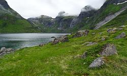
This magnificent hike takes you to the lost Hermannsdalen Valley. At the end of the valley, facing the ocean, there is an old abandoned farm, a sign of times not so long ago when people still lived in this extremely isolated part of the islands. This is one of the few hikes that takes you to the virtually inaccessible west coast of the island of Moskenesøya. Hermannsdalen is the perfect place in which to set up camp in a magnificent, peaceful landscape only 4 hours’ walk from Vindstad…
More information about this hike...
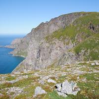
Despite two tricky sections, this short hike takes you rapidly to a fantastic view point over the southern-most point of the island of Moskenesøya and Lake Ågvatnet. Located only a few kilometres from the summit of Tindstinden and of equivalent difficulty, the climb up Andstabben offers an even more impressive panoramic view.
More information about this hike...
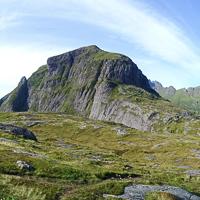
This mountain, which overlooks the tiny hamlet of Gravermarka can be accessed on a good trail which, for once, does not disappear during the hike. After a section through undergrowth you rapidly reach grazing land that offers a clear view over an amphitheatre-like rock formation and a lake. In the last part of the climb, the very beautiful open view is perfect for admiring the highest mountains on the islands. The rocky landscape of the summit is similar to that of high mountain ranges with small lakes and snow patches that remain until late in the season. A good hike, not particularly demanding, accessible any yet very few visitors, only 30 min from Svolvær.
More information about this hike...
This small summit is near the E10 road. Very few people come here as there is no trail and the base is covered with a dense birch forest. If, however, you take the time to make your way through the undergrowth following the south-east ridge of the mountain you can easily reach the summit. The viewpoints over the turquoise bay of Flakstadpollen to the north and Lake Storvatnet to the south are breathtaking.
Don’t waste time looking for the start of the trail to the summit because, at the time of writing this guide, there isn’t one. Even though there isn’t a trail there are several ways of reaching the summit, some of which are safer than others. We have chosen to follow the south-east ridge of the mountain from the small car park to the right of the road roughly 950 m after the junction of the E10 and the road to Nusfjord. You head off through the undergrowth along the edge of the road following a north-west bearing at the start. At around 200m altitude you leave the undergrowth and reach a shrub zone that gradually becomes short grassland. You can then see where you are going: look out for a small trail that appears at this level of the mountain and continues to the summit (if you don’t lose it on the way). The simplest and safest way is to follow the ridge to the summit. Even though there are a few steep sections before you reach the plateau at the summit, the view over the bay of Flakstadpollen is magnificent.
It’s possible to carry onto the pass that overlooks Lake Svartvatnet by walking down along the west ridge of Kollfjelet towards Nonstinden (see GPS route below) and coming back via the south slope of Kollfjelet mountain. If you opt for this route bear in mind that the route after the pass, and until you reach the south-east slope of Kollfjelet, is not easy because, in addition to the fact that there is no trail, the slope is very steep.
The simplest way is therefore to go back to the car park from the summit the same way as you came.
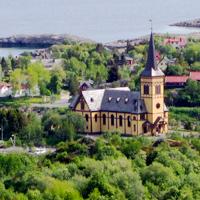
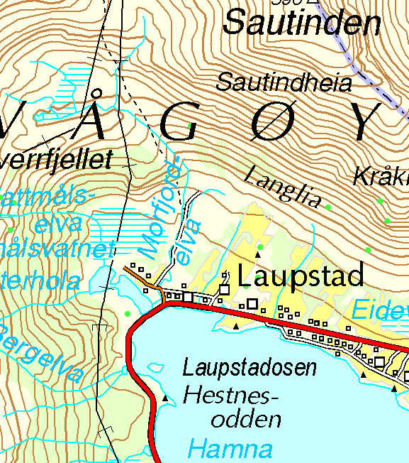
This relatively easy hike near the Lofotr Viking Museum in Borg includes a good trail over the entire distance, which is so unusual in the Lofoten islands that it needs to be emphasised. It climbs up the gigantic hill of Helfjellet to the north of the island of Vestvågøya.
From the summit of Finnkjerka there is a fine viewpoint over the north of the islands. Weather permitting, and depending in how the mood takes you, you can either do this hike as a round trip climbing to the summit of Veten (414m), or in a loop hiking past Åland farm in which case you will have to go back along the trail to Straumgård. Lastly, by following the trail along the ridges, it’s possible to reach Vardheia (325m) where the Vikjorda-Brustranda hike and “The Great Crossing of the Lofoten islands” cross.
The trail leaves from the car park (marked as “P” on the map on the bend after Straumgård) and climbs the hill (marked 97 on the map). Shortly afterwards it heads left and climbs up a steep slope to the plateau of Helfjellet that you reach at an altitude of approximately 300 m. The trail then follows the straight edge of the plateau heading south-west. The plateau is covered with shrubs and you will see several trails that head off in different directions. It’s a good idea to walk to the end of Finnkjerka (392m) from where you have a different view of the summit of Veten. From here take one of the trails to the summit of Veten (414m). After Veten the trail goes down to a pass located above Åland farm. Between the pass and the farm the trail sometimes gets lost in the tall grasses (depending on the season). In Åland you will meet up with the trail that will take you back to your starting point. Helfjellet is an easy hike that gives you a fine viewpoint over the island of Austvågøya, and is a perfect hike for all the family.
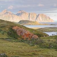
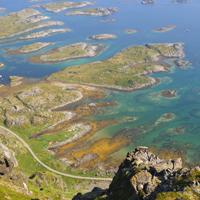
This short hike, which is accessible to everyone, explores a little-known part of the island of Vestvågøya thirty minutes or so to the south of Leknes. The starting point is the hamlet of Ure which boasts a few fine wooden houses from the late 19th century that belonged to rich fishing families. The port is surrounded by many small islands that protect it from the sometimes rough waters of Vestfjord. Behind the hamlet is a small plateau set between two mountains, it opens to the east and to the west over the fjord. Attractive Lake Urevatnet overlooks the plateau.
In the village take the first path on the right (GPS N68° 05.727' E13° 43.508') and climb it virtually to the end (GPS N68° 05.623' E13° 43.416') where you take the trail there heading south/south-west. The trail climbs quickly up to the plateau (around 50m altitude) and continues on the south side of the plateau between the foot of the mountain of Ureberget and a huge swamp zone marked on the map (Myran) and reaches the small pass of Fallet. From the pass take the right-hand trail that climbs north-west towards Lake Urevatnet.
Roughly 200m before you reach the lake, on your left you will see a sheep trail that follows the Åmundtinden ridge and which, after some considerable exertion, takes you to the summit of Breidtinden on your right and Middagstinden on your left. Caution: If you opt for this route remember that the level of difficulty is not the same. Near the lake you will come across a recent building of large raised stones (housing a boat). From this point take the small trail towards your right (east), again you will walk past a tiny lake (which is not marked on the map) before reaching the highest point of the hike in Rabban (120m) from where there is a fine view over the fjord and the hamlet below. The trail goes back down near abandoned farming land and the foundations of a farm. Then, once you have gone through a sheep fence, you go back down on an old stone road and take a trail on the left that leads to the hamlet of Ure (GPS - N68° 05.685' E13° 43.403').
Urvatnet is a nice ramble that is possible virtually all year round.
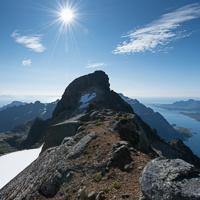
This short climb leads to a narrow pass where there is a breathtaking panoramic view over the village and fjord of Reine.
Take the old road, which has since become a cycle lane and which avoids the tunnel south of Reine. The starting point of the track lies to your right at point N67 55.381 E13 04.745 (roughly 200m after the old road coming from Reine). The track begins in a wooded area before quickly reaching the south slope of Mount Reinebringen.
The track then begins to climb a very steep slope and crosses ravines and slippery spots that can be dangerous if the ground is wet or if you stick too closely together (risk of falling rocks).
After a climb which is so steep that you will probably be head down most of the way, you suddenly reach a pass overlooking a sheer drop with the village and fjord of Reine below. The view is simply breathtaking!
From the peak you can take the track on your left to the small peak 150m away where view is more open.
WARNING we strongly advise you not to continue any further along these peaks westwards. In recent years some hikers have taken the risk and never returned!
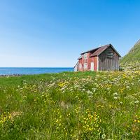
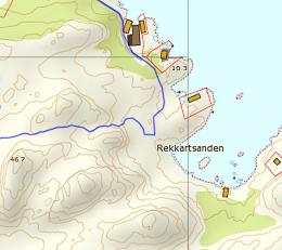
Ånstad is a 19th century former fishing village that was finally deserted in the 1940s when the inhabitants moved to larger villages such as Sørvågen. Today there remains only the landing-stage of the old port and a few foundations of houses scattered over the heathland.
More information about this hike...
Route proposed par hr.frosk
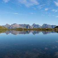
One of my top three favourite trips in Lofoten. After only 30 min walking, you will discover the magnificent gulf around Moskenesvatnet. You can access this paradise either from the churchyard of Moskenes or from Sørvågvatnet.
The trip up is, as already mentioned, short and with no complications. When you are there, you have a lot of possibilities in regards of which peaks you want to visit, but I recommend to take all of them. Gylttinden might be challenging for someone, with a quite steep approach.
The path is perfect except for the one east of Moskenesvatnet, which isn’t very clear.
This long hike, which crosses the island of Flakstadoya from north to south, takes you to the small hamlet of Nusfjord, a UNESCO World Heritage Site. The first section of the route goes along the shore of Nappstraumen, the stretch of sea that separates the islands of Vestvagøya and Flakstadøya. Don’t be fooled by the apparent flatness of this coastal hike.
More information about this hike...
Track proposed by Halfdan Holm
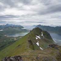
When you walk in Lofoten you often walk just straight up to the peak, and straight down again. Personally I love walking on ridges, and this is one of the few places in Lofoten where you can do exactly that.
More information about this hike...
")