Documentation
Bibliography, maps, useful links ...
")


Bibliography, maps, useful links ...
 Maps Company is selling travel and hiking maps for all over the planet. The products are shiped within 24 hours, all over the world. They offer over 17,000 travel and hiking maps (over 200 countries).
To order hiking maps for the Lofotens, click here
If you want to go from Forsfjord power station to Vindstad (or vice versa), and you don’t want to rely on the boat shuttle MS Fjordkyss, it is now possible to do it by foot.
We provide GPX track, map and the description (in french only) for the section connecting Vindstad to Forsfjord. This new possibility is particularly interesting for hikers engaged in the great crossing of the Lofoten Islands trek.
As we are not a tourist office, we will only publish recommandations for places we think are hikers and backpackers friendly and that we have tested AND appreciated. This section will get more stuff as we go along.
We have 1102 guests and 2 members online
Updated every 40min
North of the archipellago |
 |
| Laukvik |
 |
| Brotoy: E Raftsundet |
 |
| Kabelvag: Ip kamera skistua, kongstind |
 |
| Henningsvær - Austvågøya |
Center of the archipellago |
 |
| Steine: F Hagskaret (Retning Stamsund) |
 |
| Ballstad: havn i Lofoten, Vestvågøy, Nordland |
South of the archipellago |
 |
| E10 Kåkernbrua - Moskenesøya |
 |
| Vindstad: E Akkarvika |
161,424 users, 24,000 subscribers and over 1,500,000 pages viewed in 2018!
To find out more about all the Rando-Lofoten visitor statistics with accurate data from Google Analytics, click here.
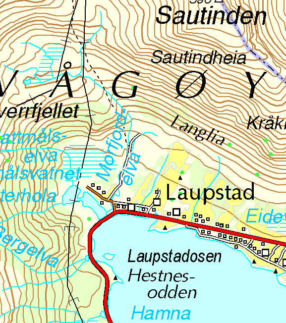
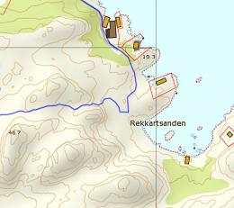
Increasingly accurate maps!
The Day Walks section has been improved thanks to the work of Frank Ingermann and the fantastic vector map background of Norgeskart.no (Norwegian Mapping Authority - Karverket). Hiking-Lofoten offers hiking guides that are getting ever more accurate and professional. Come and find out about them!
Download the official Lofoten Islands maps
Lofoten Islands maps, scale 1:50 000 (UMT33) download them for free on hiking-lofoten!Maps from the Norwegian National Institute of Cartography (Kartverket) are available in high definition (Tiff) on a set of ten maps. Essential to prepare your hikes in the Lofoten Islands...
Northern lights forecast
Discover aurora forecast for Lofoten islands, thanks to NOAA POES satelitte from the "National Oceanic and Atmospheric Administration"
GPS routes
Day Length in the Lofoten
The Lofoten archipelago is located above the Arctic Circle, the result of this situation is a period of permanent days in summer and at the opposite a period of permanent night in winter (polar night).
To organize properly your trips and expedition in this region, it is important to take this phenomenon into account due to the high latitude. Discover our sunset/sunrise calendar
Copyright
Any representation whether total or partial of this site or content (general structure, texts, sound, logos, images whether animated or otherwise), by any method whatsoever, without the authors express prior approval is prohibited and constitutes infringement sanctioned by the Intellectual Property Code. The GPX tracks that can be downloaded on this website, bellong to hiking-lofoten and is for a private use only (not for commercial use). In order to reproduce the tracks in any form or on any medium (paper, digital, website, etc.), we ask you to mention the following (under or on the map): GPX track © hiking-lofoten.net