Hiking to Bulitinden and Guratinden
Medium
Vestvågøya
5 hrs
9.88 km
650 m
576 m
Vestvågøy
Until June on the top
- Type of hike : Go back
- Visibility of the route : Good
- Start/Finish : 
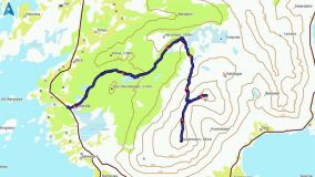
Nedreås Bus-stop (Route 997 - Ramviksveien)
- GPS Point : Start/finish : N68 07.415 E13 38.685
Pass : N68 07.463 E13 41.566
Bulitinden summit : N68 07.517 E13 41.962
Guratinden summit : N68 07.112 E13 41.358
Description
Although these two beautiful peaks above the town of Leknes (Vestvagoya) are easy to climb, they offer a spectacular panorama of the central part of the Lofoten Islands.
More information about this hike...
You can read the detailed description of this hike (as well as 59 other hike descriptions), enjoy hundreds of photos, maps and practical information on the paper guidebook Hiking the LOFOTEN ISLANDS. |
Accessibility
Yes
Yes
Yes
Slideshow
View the embedded image gallery online at:
https://rando-lofoten.net/en/guratinden-en?tmpl=component&print=1#sigProId646609637f
Download the route | Guratinden.gpx |
Join the start of the hike with Google Maps
You can use your actual location or enter the name of the place from which you wish to start