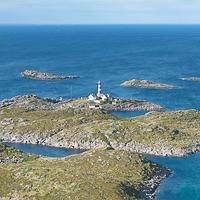
Hiking to Skrova

Difficulté 1
Skrova
2 to 3 hrs
8.2 km
520 m
264 m
Vågan - 1:50 000
Until March
Type de rando :
Loop
Visibilité du sentier :
Bonne, Moyenne
Départ/Arrivée :
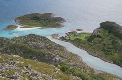
From the ferry dock, follow the asphalt road on your right that goes to the main island. The road goes over two little bridges. About 100 m (110 yd) after the second bridge, an unpaved road begins on your left with an informative panel about the different itineraries you can take
Point(s) GPS :
Starting point(ferry dock): N68° 10.013' E14° 39.751' Trail start: N68° 09.976' E14° 40.626' Trail end : N68° 10.016' E14° 41.725' Summit of Stappen : N68° 09.548' E14° 40.292' Summit of Høgskrova: N68° 09.762' E14° 41.404'

Description


The variety of natural landscapes in a limited space where you can sense the ancient presence of man gives Skrova the atmosphere of a miniature world. You can observe it as long as you like from the top of Høgskrova. We’ve already seen that the local community takes particular care to mark and maintain the different trails in the most isolated places. Thus you’ll find several itineraries with colored dots showing you the way, as well as a panel summarizing the hike at the start of the main path.


More information about this hike...

Cover EN ptYou can read the detailed description of this hike (as well as 59 other hike descriptions), enjoy hundreds of photos, maps and practical information on the paper guidebook Hiking the LOFOTEN ISLANDS.
You'll find the guidebook on logo amazon en, as well as at the following bookstores, for 24,07£ (not including shipping).

Order on Amazon

Accessibilité

Accessible to dogs, Family friendly

Diaporama