Hiking to Tønsåsheia


- Type of hike : Go back or loop if the two routes are combined
- Visibility of the route : Good to medium if first route, poor to non existant if second route
- Start/Finish : 
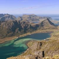
Park in Nusfjord, the trailhead start at the endof the dirt road (on the other side of the village).
- GPS Point : Start/finish: N68 02.096 E13 20.945
Trailhead: N68 01.750 E13 20.935
Turn rightat this point: N68 01.741 E13 20.635
Turn rightat this point: N68 01.560 E13 18.618
Tønsåsheia summit: N68 01.865 E13 17.499
View point: N68 02.053 E13 17.233 - Extensions : itinéraire 2, moyenne+, 5h, 7,8km, +/-870m, '769m
The peak of Tønsåsheia rises up between the village of Nusfjord and the fjord of Skjelfjord. It is the starting-point of an impressive chain of peaks that are difficult to climb and which run as far as the village of Ramberg to the north of the island of Flakstad. From the top there is a magnificent panorama of the turquoise waters of Skjelfjord, the Vestfjord and Stjerntinden (934 m), the highest peak on the island. What’s more, despite the steep slope it is easy to get to the top and the path is clearly visible all along the route.
More information about this hike...
|


https://rando-lofoten.net/en/tonsasheia-en?tmpl=component&print=1#sigProId3e42984059

Download the route | Tonsasheia.gpx |
Join the start of the hike with Google Maps
You can use your actual location or enter the name of the place from which you wish to start

Download the route | Tonsasheia_Nesland.gpx |