Hiking to Håtinden
 Medium / Difficult
 Vestvågøya
 4 hrs
4 hrs 9.7 km
 900 m
900 m 662 m
662 m Vestvågøy
 Until May at the top
- Type of hike : Go back
- Visibility of the route : Non-existent
- Start/Finish : Coming from Leknes, take E 10 north to the entrance of the hamlet of Lyngedal on the northwest tip of Vestvagøya Island. About 300m before the entrance to the hamlet, in the bend in the road between Lyngedalspollen and Lake Lyngedalsvatnet, you'll see a little parking space in front of an old wooden shack. You can stop at this spot. A sign gives basic explanations about the different trails of the sector. This spot is also the starting point for the Hellostinden hike.
- GPS Point : Start/Finish (Small parking lot close to the E10) : N68° 15.505' E14° 02.447'
Trail start - behind the old farm : N68° 15.372' E14° 03.088'
Lygdalsheia plateau: N68° 15.466' E14° 03.847'
Håtinden summit : N68° 14.927' E14° 04.852'
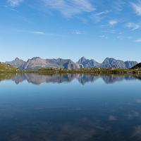
Litlhåtinden pass : N68° 14.523' E14° 04.748' - Note : Many of the sectors you go through in this itinerary go over boggy'in fact, sometimes marshy'ground, all covered with heather. You can see this natural characteristic in the local place names: Lyngedal, Lyngedalsheia, Lyngedalsvatnet and Lyngedalstrolldalen all have the prefix Lyng, which means heather in Norwegian.
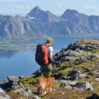
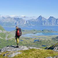
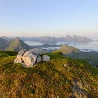
This summit on Vestvågøya Island is rarely visited, but it has magnificent panoramas in store for anyone bold enough to climb it. No crush of hikers here in any season: only a tiny passage through thick, rich vegetation that will bring you to a high mountain pasture on a plateau—the last walk before the summit. The points of view are many and varied all along this wild and sometimes difficult itinerary. We’ve described it as a round trip but it is also possible to make a great loop around Lake Lyngedalsheia.
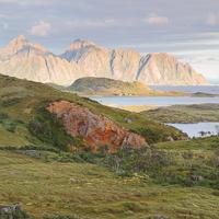
To get to the tiny trail that climbs the west slope of Lyngedalsheia through the forest, you’ll first have to reach the old farm at the end of the path that goes along the east bank of the lake. You can either reach this path by walking along E10 for a hundred yards or so, or by going along the northern tip of Lyngedalsvatnet Lake. To do the latter, you’ll have to cross the stream that flows from the lake by going over some rocks. At the end of the path, you come upon an old farmhouse. A very small trail starts behind it, cut into the woods and marked out from time to time by red plastic posts. You’ll have pay very close attention to follow these discreet markings without losing them, especially when the vegetation is high. After a rather steep climb up the undergrowth, you reach the Lyngedalsheia plateau, a vast bog covered by very low plants. From the plateau, you’ll have your first point of view over the north and Gimsøya Island. Cross the plateau to reach its eastern side. From there, you can walk due south toward the northwest ridge of the Håtinden summit. There is no real trail but you can see a few signs of passage (mostly sheep) on the eastern border of the plateau as well as on the ridge leading to the peak. A small passage lets you climb the ridge to the summit. Avoid the scree and other fallen stones covering the slopes of the mountain as much as possible, but sometimes you’ll have to use your hands to get through the rocky passages.
The summit gives you a fantastic panorama, particularly out toward Austvågøya Island and the wide arm of the sea that separates it from the island of Vestvågøya. From the summit, you can keep going toward the southeast and reach the southern ridge of the mountain in the direction of Litlhåtinden up to a small pass at an altitude of 450m (1,476 ft). The passage between the Håtinden summit and the pass gives you a series of fabulous, varied landscapes.
Go back the same way. Even if it seems tempting, it is a very bad idea to go down into the little valley to the right of the pass to reach Lake Lyngedalsvatnet: if you opt for this “solution”, the tree-covered part of the valley and the return by the right bank of the lake are totally off trail and you’ll spend much more time and energy than if you returned by the summit.
From the pass, it is possible to keep going toward Vikjorden, and then, in passing by Kitaksla (532 m / 1,745 ft), to reach the southern tip of Lake Lyngedalsvatnet. To do this, you have to go around the Vikjordtinden summit by the south, at an altitude of roughly 500 m (1,640 ft) and then take the passage by the Kitaksla ridge and reach the little trail toward Finnvollen one way or another. From there, after you cross a vast boggy plain, you can get to the left (west) bank of Lake Lyngedalsvatnet and walk back to your starting point.
Watch out! This latter option is really difficult: it has passages that are precipitous and others that are steeply banked. What’s more, you won’t find a trail there worthy of the name.
 No
No No
No No
No
https://rando-lofoten.net/en/hiking-to-hatinden?tmpl=component&print=1#sigProId1a3ae43afe


Download the route |
Hatinden-649.gpx |
Join the start of the hike with Google Maps
You can use your actual location or enter the name of the place from which you wish to start