


Go back
Mauvaise, Inexistante
This hike is in the North-East of the large island of Vestvågøya. Coming from Stamsund, take the pretty coastal road 815 as far as the road-sign for Vikjorda. A little further along on the left you will see a house standing on its own by the roadside. This is the Rebecca café. The path begins to the left of the café (on its southern side). This is the same starting-point as for the Dalstuva hike and the hike across the island of Vestvågøya.
Start/Finish : N68 13.642 E14 04.616
Summit Kotaksla : N68 14.151 E14 03.857
Point where you should leave the ridge of Vikjordtinden : N68 14.220 E14 04.558
Summit of Vikjordtinden : N68 14.258 E14 04.591
Description
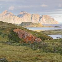
This impressive peak overlooks the tiny hamlet of Vikjorden. Looking up at it, the peak looks completely inaccessible, but there is in fact a very safe path to the top from where the view is absolutely fabulous!
More information about this hike...
|
|

Accessibility
Not defined


