Why hike in the Lofoten Islands?

To this question I would simply answer, “Because you find everything hikers dream of concentrated in a limited area!”

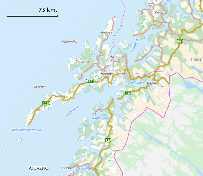
It is often said that the Lofoten Islands are a miniature Norway, which is true because all the landscapes you find in mainland Norway are within easy reach.

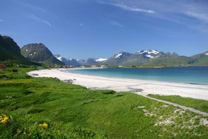
Outstanding landscapes and light.
Here you will find immense white-sand beaches, small ports with brightly coloured houses nestling deep in tiny fjords, narrow valleys with a few isolated farms dotted here and there, green or flowery plateaus, mountain lakes, tumultuous waterfalls, breath-taking snow-capped mountains, all bathed in the northern light of which photographers are so fond. The wide range of landscapes, the ever-present sea and mountains as well as the purity of the light are unique in the world.

Fabulous, wide-open nature. Here the only barrier to unrestricted travel is the mountains. As everywhere in Norway, the few, generally quiet inhabitants here are not sticklers about private property. Many hiking trails pass through farms or alongside isolated houses and if you happen to meet someone they are sure to wish you good day and a good trip in Norwegian. The few sheep fences you encounter always have a ladder or gate nearby which you should always close behind you. This total freedom must not make you forget that the natural environment you are passing through is fragile and unused to large mammals like us.

Lofoten floraMuch of the islands is covered with peat that grows slowly at a rate of 1 mm a year! This fragile biotope means you have to be particularly careful and try to  walk on the existing paths wherever possible. Sheep – which are the main inhabitants of the wildest parts of the islands – have created a certain number of tracks but beware, they won’t always take you where you want to go.

Read more: Why hike in the Lofoten Islands?

Location

The Lofoten Islands belong to Norway and form an archipelago 300 km to the north of the Arctic Circle. The archipelago extends from the 67th to the 69th parallels and is roughly 150 km long. It is about fifty km west of mainland Norway.

 
(©norkart AS - Atlas.no)
The archipelago is made up of seven main islands that are permanently inhabited and connected to the mainland by bridges. On the other hand, Værøy and Røstland to the extreme south can only be reached using the regular ferry services. 


The archipelago is separated from the Norwegian mainland by Vestfjord, a gigantic fjord (90 km wide at the mouth) which ends in Narvik 300 km further north. The widest part of Vestfjord to the south of the Lofoten Islands resembles an inland sea.

(©norkart AS - Atlas.no)

Read more: Location

Topography

Topographic map of Lofoten
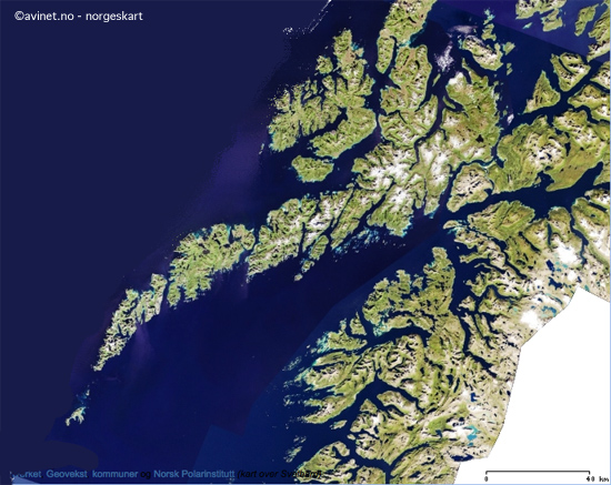
What makes the Lofoten Islands unique is the combination of landscapes and terrains that are not usually found together. Over 80% of the archipelago consists of a mountain range with its jagged peaks.

The remainder is made up of small plateau areas in the centre and to the north and a narrow coastal strip where most of the population lives. In a single day you can begin hiking on a wide golden-sand beach looking out to the Norwegian Sea then cross mountain pastures inhabited by a few half-wild sheep before finally arriving at steep peaks still partially covered with snow even though it’s mid-August!

This permanent contrast never fails to surprise hikers and leaves no room for monotony. It is often said that the Lofoten Islands are like the Alps with their feet in the sea.

A range of peaks in Moskenesoya in early spring
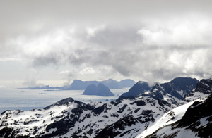
The Lofoten Islands, like the rest of Norway, are made up of terrain that is extremely wild and untamed. But this is also what makes them so attractive. But hiking in such terrain is not without its difficulties! In the north of Norway there are few hikers and therefore few paths which is why most hikes are “off track” on rough scree. The thick covering of vegetation conceals the unevenness of the land. Here more than anywhere you should not judge the difficulty of hikes in terms of steep slopes or distance, but in terms of the nature of the terrain which is comparable to high mountain areas.


To ensure that your trip remains pleasant for you and anybody travelling with you, you must not only be in good physical condition but also have experience hiking in mountains over rough terrain. You will be the first to benefit once there.

Read more: Topography

Climate

Ramberg beach - Lofoten

The Lofoten Islands , like a large stretch of the west coast of Norway, enjoy an exceptional climate. At this latitude, without the warm currents of the Gulf Stream the islands would be covered with ice and no vegetation could grow. In fact the warm marine currents from the North Sea give the archipelago a mild oceanic climate with average temperatures in January of 1°C in Røst to the south of the islands (in other words higher than those in mainland France at the same time of year) and cool summers with an average of 13°C in July.
Even though the temperature may occasionally rise to 30°C in July, it is common to have fine days with temperatures of 25°C during the three summer months.
But, attractive as the climate may seem, remember you are in an arctic region near the North Pole and temperatures can drop suddenly, which is why you need appropriate protective clothing (see Equipment).

I would now like to set the record straight regarding certain misconceptions about rain. Having spent every summer in the Lofoten Islands in the last ten years, as well as the ten previous years in the south-west of Norway, I can assert that, contrary to certain rumours, it does not rain constantly in the Lofoten Islands!

Read more: Climate

Search the site ...

Connection

In order to access certain services available on our site, (participation in forums, access to hiking sheets) you must register.

Our tips

Where to sleep, eat, drink and more in the Lofoten Islands

As we are not a tourist office, we will only publish recommandations for places we think are hikers and backpackers friendly and that we have tested AND appreciated. This section will get more stuff as we go along.

Latest news

 Visitor statistics

161,424 users, 24,000 subscribers and over 1,500,000 pages viewed in 2018!

To find out more about all the Rando-Lofoten visitor statistics with accurate data from Google Analytics, click here

 Increasingly accurate maps!

The Day Walks section has been improved thanks to the work of Frank Ingermann and the fantastic vector map background of Norgeskart.no (Norwegian Mapping Authority - Karverket). Hiking-Lofoten offers hiking guides that are getting ever more accurate and professional. Come and find out about them!

norgeskart-


Download the official Lofoten Islands maps

Lofoten Islands maps, scale 1:50 000 (UMT33)  download them for free on hiking-lofoten!Maps from the Norwegian National Institute of Cartography (Kartverket) are available in high definition (Tiff) on a set of ten maps.  Essential to prepare your hikes in the Lofoten Islands...

Lofoten maps

Northern lights forecast

Discover aurora forecast for Lofoten islands, thanks to NOAA POES satelitte from the "National Oceanic and Atmospheric Administration"

GPS routes

  • The GPS hiking routes are finally available as free downloads from the Hikes section!
  • Discover eight new routes in the Lofoten Islands with detailed Topos from Rando-Lofoten.

Day Length in the Lofoten

The Lofoten archipelago is located above the Arctic Circle, the result of this situation is a period of permanent days in summer and at the opposite a period of permanent night in winter (polar night).

To organize properly your trips and expedition in this region, it is important to take this phenomenon into account due to the high latitude. Discover our sunset/sunrise calendar

Copyright

Any representation whether total or partial of this site or content (general structure, texts, sound, logos, images whether animated or otherwise), by any method whatsoever, without the authors express prior approval is prohibited and constitutes infringement sanctioned by the Intellectual Property Code. The GPX tracks that can be downloaded on this website, bellong to hiking-lofoten and is for a private use only (not for commercial use). In order to reproduce the tracks in any form or on any medium (paper, digital, website, etc.), we ask you to mention the following (under or on the map): GPX track © hiking-lofoten.net