Forum
Participez aux différents Forums sur notre site, posez des questions, proposez des nouveaux sujets de discussion, faites part de votre expérience. La consultation des Forums est ouverte au public, si vous souhaitez intervenir sur les différents Forums, il vous suffit de vous inscrire ou de vous connecter (si vous avez un compte). Cet espace de Forum est contrôlé par un modérateur. Toute intervention ayant un caractère commercial, haineux ou raciste n'a pas sa place ici.
Avant d’intervenir sur le forum, merci de vérifier les points suivants :
- Que vous êtes dans la bonne rubrique par rapport au sujet que vous voulez traiter.
Que le sujet n’a pas déjà été traité sur ce site ou dans le Forum.
Pour vérifier ceci, il vous suffit d’aller sur la page d’accueil par exemple et utiliser l’outil de recherche qui se trouve en haut à droite. Entrez simplement les termes de votre recherche (ex. : cartes Lofoten) et la recherche se lance automatiquement. Si vous ne trouvez pas ce que vous cherchez sur le site, vous pouvez également lancer une recherche sur le Forum, grâce à son outil de recherche spécifique, qui se situe au-dessus de la liste des « Sujets » à droite. Si vous ne trouvez toujours pas de réponse à votre question, nous vous invitons à la poser sur le forum.Attention, les informations redondantes seront supprimés.
Bonne participation …
Le Modérateur
Connexion
")


Hi,
I will spent a week in Lofoten islands across Easter and I was wondering which are the best hikes to do.
Since it will be still April, I will assume that I will find snow basically everywhere and also the risk of avalanches can be medium-high.
Considering all this, do someone have suggestions for hikes?
I will have snowshoes with me, but I don't know the area and where it's best to go. Of course I will prefer hikes that are also panoramic or have a great view from the top.
Thanks a lot for your help
Ilfo
Ven 12 Avr, 2019, 11:13 am
Just pick up the walks marked with the snowshoes picto  . The easiest island in winter condition is, without any doubt, Vestvågøya.
Have a safe hiking journey
david
Ven 3 Mai, 2013, 5:06 am
Hi David,
thanks for the answer.
But do you think it's for sure needed the snowshoes? Because I have them with me but I don't know exactly the amount of snow present at the moment, do you think it's impossible to do hikes that doesn't have the snowshoes picto?
Anyway, if it's not a problem later this day I will write down the hikes that I prefer and could you please advise me on them?
If you are leaving in Lofoten we can meet and I can buy you a beer ![]()
Ilfo
Ven 12 Avr, 2019, 11:13 am
Here you have a list of the hikes we will like to do (of course not all of them but only some):
- Volanstinden peak
Ballstadheia plateau
Blåtinden peak
Holandsmelen Hill
Offersøykammen summit
Tjeldbergtiden hike
Lake Ågvatnet
Hermannsdalen hike
If you can give me any info about those will be amazing and as I say we can meet and we will offer you a beer ![]()
Ilfo
Ven 12 Avr, 2019, 11:13 am
I would be interested to know how your trip turned out and what hikes you were able to do. We will be there for a week starting 5/3 and have similar ambitions.
Any information upon your return would be much appreciated!
Thanks in advance.
ard1165
Lun 22 Avr, 2019, 4:30 pm
I received an email saying that there was a reply to my discussion asking for more info but I can't see it right now.
Anyway I will post a small recap of the hiking that I made and of the conditions that can be helpful for others future hikers.
First of all I will like to say that not all the trails are perfectly marked (and sometimes covered by snow) but if you have a watch that can follows tracks will be better for sure (why do not mark the tracks also for winter hikers?).
Another suggestion is to ask at one of the several info points in Lofoten so they can suggest you hikes to do or to avoid since there can be a lot snow in some areas (at Ramberg info point there was a really nice guy that were suggesting us different hikes).
19/04/19 Ballstadheia https://www.rando-lofoten.net/en/ballstadheia-en
We didn't do all the trail because it was too cloudy and windy and since we didn't know the route we prefer to avoid to climb up to the top and just stop at the start of the climb.
It's an easy trail along the fjord and some parts are through the rocks so can be easy to lose the trail but it's really nice (we saw a lot of eagles on the way).
Approximately we walked 6.5km with 390m of elevation, 2 hours walking (consider 3 hours since you will stop for pictures ecc)
20/04/19 Kvalvika and Ryten https://www.rando-lofoten.net/en/fredvang-kvalvika-en
You should do this one. It's really amazing and the views are excellent. We did all the trail and some part of it are steep and rocky but not too difficult and the tracks are well marked. On the way down there are some parts a bit more difficult but you can manage it. Follow the tracks on the GPS or the indication since there are some crossroad or part of the track cover with the snow. At the end you will walk about 1 km along the road (no traffic so it's safe). We met a lot of people doing this hike and some parts are really swampy since the snow is melting.
13 km, about 500m in elevation and 3 hours walking (about 4 hours in total)
21/04/19 Nesland to Nusfjord https://www.rando-lofoten.net/en/nesland-nusefjord-en
Seems flat but it's not at all and some parts are a bit challenging but you will reach Nusfjord that it's a really nice village with restaurant, coffee and shop. A lot of time you will have to avoid water flowing and a lot of swampy area due to the snow melting from the mountain. Same way back.
11km, about 550-600m in elevation and 3 hours walking (about 5 hours in total since you will stop a bit in Nusfjord)
23/04/19 morning Volandstinden https://www.rando-lofoten.net/en/volandstinden-en
We didn't follow the route that Rando Lofoten suggest but we started from Skjelfjord (attached my GPS track) and it's really worth it and trail are quite easy to follow. Up there the view is amazing. Same way back
5km, 450m in elevation and 1hour and an half walking (about 2 hours in total for pictures)
23/04/19 afternoon Offersoykammen https://www.rando-lofoten.net/en/offersoykammen-en
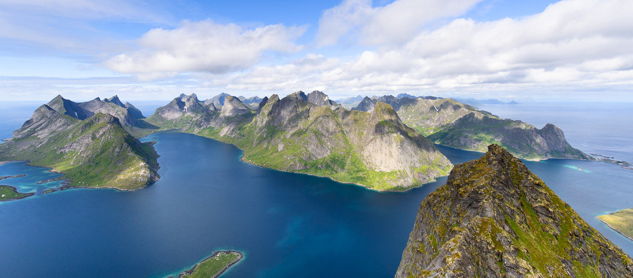
Simply amazing. Up and down from the same way, easy trail to follow and SPECTACULAR view from the top.
3km, 400m in elevation and 1 hour walking (about 2 hours in total for pictures).
24/04/19 Justadtinden https://www.rando-lofoten.net/en/justadtinden-en
This was the most challenging (physically) since it's quite long and there is a lot of snow, I will recommend snowshoes for a lot of parts otherwise you will get all your hiking boots completely wet. The last part is very steep and for some parts we avoid the snow and prefer to go through the rocks.
Halfway up you will be completely in the snow so you need a GPS track to follow in order to find the exact route. The view are also here ASTONISHING, all the way up you get more and more land that you can see if you turn, and all the way back it's amazing since you have a spectacular view.
If you are not a bit expert in hiking maybe avoid this one since can be scary at the top, anyway we met people going up and down skiing. Since there is a lot snow, ask at some info point information about it to avoid risk of any kind.
13,3km, about 800m in elevation and 4 hours walking (consider 6/7 hours due to pictures and lunch stop).
Lofoten are amazing and if you are lucky with the weather you will have spectacular views and when you are leaving you will very sad.
Last tip: if you are travelling by plane to and from Svolvaer sit on the right side of the plane on the way to the island and on the left side when you are leaving ![]()
Hope this post can be helpful and if someone have other question that I can answer I will be glad to do it.
Ilfo
Ven 12 Avr, 2019, 11:13 am
Copyright et droit d'auteur
Toute représentation totale ou partielle de ce site ou son contenu (structure générale, textes, sons, logos, images animées ou non), par quelque procédé que ce soit, sans autorisation préalable et expresse auprès des auteurs de Rando-Lofoten, est interdite et constituerait une contrefaçon sanctionnée par le code de la propriété intellectuelle. Tous les textes du site ont été déposées auprès de la SDGL. Les tracés GPX, téléchargeables gratuitement sur ce site, appartiennent à rando-lofoten et peuvent être utilisés dans un cadre privé, non commercial. Pour pouvoir reproduire ces tracés, quelque soit le support (papier, numérique, site internet, etc.) il faudra obligatoirement indiquer la source (sur ou sous la carte): tracé GPX © rando-lofoten.net