


Go back
Moyenne, Mauvaise
Youth house facing the stockfish racks at the entrance of Skjellfjordenon the right hand side of the road (N68° 03.909' E13° 14.237')
Start/finish: N68° 03.909' E13° 14.237'
Summit: N68° 02.449' E13° 13.029'
Description
Route proposed par Halfdan Holm
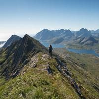
You park your car at the youth-house in Skjellfjorden and follow the clear path near a small shelter up to Nesheia. Here the path continues up to Volandstinden, so you’ll have to start following the GPX-track south towards Blåfjellkammen.
Now you can stop at (N68° 02.830' E13° 13.126') if you don’t have a head for heights, because you will actually only gain two extra meters by continuing on the edge. But it is a very nice edge, so if you have the time is it very much recommended to take the extra trip. Same way back.
Accessibility
Not defined


