


Go back
Bonne
Small parking on the right hand side of the road E10, coming from Ramberg (N68° 06.155' E13° 18.244')
Start/Finish : N68° 06.155' E13° 18.244'
Summit : N68° 05.880' E13° 17.576'
Description
Route proposed par hr.frosk
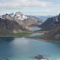
The trip up to Flakstatinden, or the "Gina's-Route" was inaugurated in 2013 by the Norwegian Queen to celabrate the 100 years anniversary of women’s voting rights in Norway. It was named after Gina Krog an activist from Flakstad fighting for the women's voting right.
It is therefore a very good and clear path. One of the best in Lofoten. It is a short and easy trip where you gain altitude fast, and is a little bit steep during the last hundred meters. Halfway up you find a nice small shelter. Return same way.
Accessibility
Not defined


