


Go back
Bonne
The trail starts on the right along the E10 road coming from Leknes, approximately 900m after the bridge that spans Offersoystraumen.
Start/Finish: N68° 09.266' E13° 30.836'
Summit: N68° 09.667' E13° 30.109'
Description
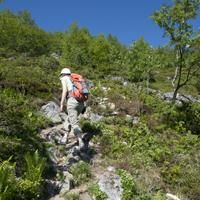
This small peak near Leknes on the peninsula of Offersøya is where a certain number of runners from the neighbouring town meet, you often see them jogging on the trail! Even though the altitude at the top is less than 450m, the panoramic view it offers is fantastic.
More information about this hike...
|
|

Accessibility
Accessible to dogs, Family friendly


