")


| hhhhhhhhhhhhhh | ||||
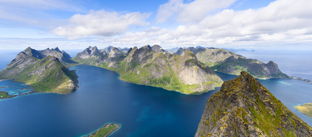
8 nouveaux topos de randonnées sont disponibles gratuitement et accessibles pour les utilisateurs enregistrés. Tous les topos que nous proposons sont réalisés par notre équipe, ce qui veut dire que chaque randonnée est préalablement testée et que toutes les informations (tracés gps, indications topographiques, etc.) sont collectés et vérifiés par nous même. | IMAGE 1 | |||
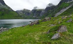
| Une rubrique consacrée aux Aurores Boréales C’est maintenant la pleine saison pour observer ce phénomène physique spectaculaire. Nous vous proposons des outils en ligne de prévision des aurores boréales, ainsi qu’une galerie de photos « fraîchement » prise des dernières aurores observées aux Lofoten. Une mini-galerie de photos des Lofoten en hiver ainsi que des actualités locales qui ont attirés notre attention de randonneurs et d’amoureux de la nature arctique et qui vous permettrons sans doute de mieux appréhender l’hiver dans cette région du globe. | IMAGE 2 | |||
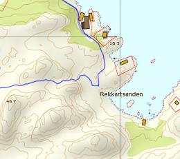
Hiking All the routes we offer have been drawn up by our team, which means that each hike is tested beforehand and we have collected and tested all the information (satnav routes, hiking specifications, etc.). | IMAGE 3 | |||
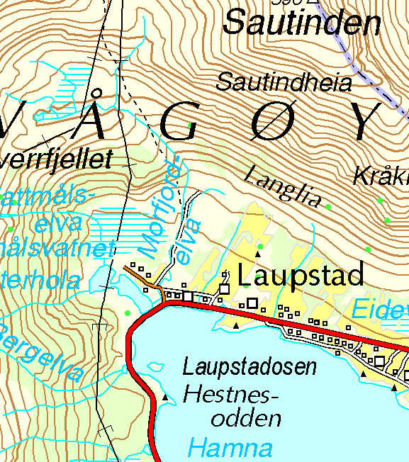
| Site A section dedicated to the Northern Lights This is now the best time of the year to observe this spectacular natural phenomenon. We provide on-line tools for forecasting the Northern Lights, as well as a gallery of recently taken photos of the latest display of Northern Lights in the Lofoten Islands. A mini-gallery of photos of the Lofoten Islands in the winter and local news that we have spotted as hikers and arctic nature lovers that will give you a better idea of what winter is like in this part of the world. | IMAGE 4 | |||
newsletter 3
Search the site ...
Advertisment
Planning your hiking trip to the Lofoten Islands?
Don't wait to be on site, and get them online at the "Maps Company", our official partner.
 Maps Company is selling travel and hiking maps for all over the planet. The products are shiped within 24 hours, all over the world. They offer over 17,000 travel and hiking maps (over 200 countries).
To order hiking maps for the Lofotens, click here
Connection
Boat Shuttle
Reine/Vindstad/Kjerkfjord
If you want to go from Forsfjord power station to Vindstad (or vice versa), and you don’t want to rely on the boat shuttle MS Fjordkyss, it is now possible to do it by foot.
We provide GPX track, map and the description (in french only) for the section connecting Vindstad to Forsfjord. This new possibility is particularly interesting for hikers engaged in the great crossing of the Lofoten Islands trek.
Our tips
Where to sleep, eat, drink and more in the Lofoten Islands
As we are not a tourist office, we will only publish recommandations for places we think are hikers and backpackers friendly and that we have tested AND appreciated. This section will get more stuff as we go along.
Who is online ?
We have 1756 guests and 2 members online
- PatrickNoust
Lofoten Webcams
Updated every 40min
North of the archipellago |
 |
| Laukvik |
 |
| Brotoy: E Raftsundet |
 |
| Kabelvag: Ip kamera skistua, kongstind |
 |
| Henningsvær - Austvågøya |
Center of the archipellago |
 |
| Steine: F Hagskaret (Retning Stamsund) |
 |
| Ballstad: havn i Lofoten, Vestvågøy, Nordland |
South of the archipellago |
 |
| E10 Kåkernbrua - Moskenesøya |
 |
| Vindstad: E Akkarvika |
Forum's latest posts
- Lofoten en février en autonomie
- Randonnées durant la nuit polaire
- Hopital / Urgences / Medecin généraliste
- Balade avec un enfant de 6 ans
- Flying to Lofoten
- Ferry to Vinstad timetable 2020
- Detailed Guide on Hiking in Lofoten
- Cash required on the "grande traversée"
- Reinebringen and Helvete (Veinestinden)
- Fishing on Moskenes
- Traversée des Lofoten, sens préférentiel?
- Hiking during the dark period
- Ferry de Bodo à Svolvaer 1h après atterrissage.... !
- Lecture de carte
- Randonnée 10 jours été 2019
- Besoin de précision pour les randonnées proposées
- Private boats for hire to get to Hellsegga
- étape 3 : Svolvaer - Kleppstad (Grande traversée)
- Quelles randonnées choisir ?
- COVID-19
- Randonnées en octobre
- One way hike - How to get back ? (bus, hitchhiking)
- randonnee ce mois d'octobre
- Å to Helsegga
- Livre - Plan des randonnées
- Current snow conditions
- Grande Traversée - Fjord de Kjerk-Fjorden - éviter le bateau ?
- Munken vs Veinestinden
- Sea Kayaking trip in Lofoten Islands
- Forums either not working properly for me, or been hacked?
- Rallier Munkan depuis Veinestinden (ligne de crêtes ?)
- Access denied to Munkebu hut: the illegal, discriminating policy held by the Turlag Lofoten and by the Reine InfoPoint
- Veinstinden (& Reinebringen = loop)
- Buvagen back to A
- proposition de trek autour de Moskenes
- Hermannsdalstinden in June 2020
- Top 10 peaks
- Quelques randonnées aux Lofoten
- Best hiking in August
- Consigne aéroport de BODO
Latest news
161,424 users, 24,000 subscribers and over 1,500,000 pages viewed in 2018!
To find out more about all the Rando-Lofoten visitor statistics with accurate data from Google Analytics, click here.
Increasingly accurate maps!
The Day Walks section has been improved thanks to the work of Frank Ingermann and the fantastic vector map background of Norgeskart.no (Norwegian Mapping Authority - Karverket). Hiking-Lofoten offers hiking guides that are getting ever more accurate and professional. Come and find out about them!
Download the official Lofoten Islands maps
Lofoten Islands maps, scale 1:50 000 (UMT33) download them for free on hiking-lofoten!Maps from the Norwegian National Institute of Cartography (Kartverket) are available in high definition (Tiff) on a set of ten maps. Essential to prepare your hikes in the Lofoten Islands...
Northern lights forecast
Discover aurora forecast for Lofoten islands, thanks to NOAA POES satelitte from the "National Oceanic and Atmospheric Administration"
GPS routes
- The GPS hiking routes are finally available as free downloads from the Hikes section!
- Discover eight new routes in the Lofoten Islands with detailed Topos from Rando-Lofoten.
Day Length in the Lofoten
The Lofoten archipelago is located above the Arctic Circle, the result of this situation is a period of permanent days in summer and at the opposite a period of permanent night in winter (polar night).
To organize properly your trips and expedition in this region, it is important to take this phenomenon into account due to the high latitude. Discover our sunset/sunrise calendar
Copyright
Any representation whether total or partial of this site or content (general structure, texts, sound, logos, images whether animated or otherwise), by any method whatsoever, without the authors express prior approval is prohibited and constitutes infringement sanctioned by the Intellectual Property Code. The GPX tracks that can be downloaded on this website, bellong to hiking-lofoten and is for a private use only (not for commercial use). In order to reproduce the tracks in any form or on any medium (paper, digital, website, etc.), we ask you to mention the following (under or on the map): GPX track © hiking-lofoten.net