

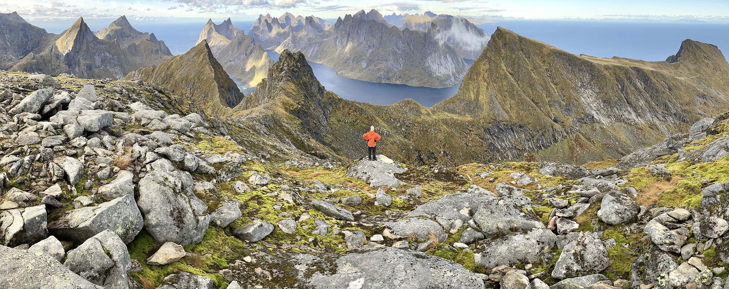
Lofoten Long Crossing
from South to North - fall 2022
Presentation
My partner and I recently hiked the Lofoton Long Crossing and we made the following notes that covers the entire trip in detail. Please take a read if you are planning your own trip. We hiked in the shoulder season starting September the 24th (2022) and finished 12 days later. We had 2 shorter days due to transportation/logistics and took five amazing side trips.
Photos and text by Vanessa Knibbs & Alex Hierl
 Day by day
Day 1, on the 24th we left our vehicle in Napp and caught the first bus of the day at 8:30 am to the southern most starting point at A-Lofoten. It took us 7 days hiking from the South to North to get back to Napp and we did not resupply at any of the shops/cafes. Our first day of hiking was Stage 11 and we found it difficult walking - the path would twist and turn and go through boggy ground and up and over rocky outcrops next to the beautiful Agvatnet. The path up and over to the waterfall at Stokkvikvatnet was very steep and slow going but we were thankful not to be carrying our heavy packs at that point. We loved the views and enjoyed the stage thoroughly despite the difficult walking. We only saw one other person all day. At the end of the day we decided to camp at a small shelter half way along the northern shores of lake Agvatnet. It was not marked on the topo map, it had a sign for Moskesnes fishing club. Our tent fit nicely on the wooden platform and it was dry and sheltered from the high winds. Other possible camping spots would have been closer to the road near the end of the stage, but we found the ground there pretty waterlogged.
Day 2, Stage 10 was long but beautiful, it started off with 2.5 km of road which we tried and failed to hitch a ride along. The upward slog to the Menkebu hut (closed) was eased with amazing views. At this stage the wind was ramping up and we struggled to find shelter behind the hut for lunch/coffee. We were glad we decided to do the recommended side trip up to Munken Nordtopp the views were phenomenal. That night we found a semi-sheltered camp on the veranda at the closed private Kookbura hut on the edge of the Kronkvatnet. The gale force winds swirled all night long and unfortunately it took off with a pair of waterproof socks and underpants: gutted. With weather like that the huge side-trip up to Hermannsdalstinden was out for us.
 Day 3, Stage 9 commenced with a steep decent to the waterfall off the north western edge of Tennesvatnet. Water spayed everywhere with fierce winds. The most obvious path down led us to cross the waterfall and due to wet and windy conditions it looked dangerous so we decided to turn back to find an alternative (marked on our map). In dryer conditions it might have been the better option. The alternative was the hydro-power pipe-line. This was steep and slippery but manageable. Some red trail markers led us down this was but the wooden makeshift ladder someone had made long ago was all broken up. The decent required a bit of scrambling and passing over our heavy bags. Getting to the fjord edge we found a heap of large mussels at low tide and so rewarded ourselves with a big steamy breakfast. The description on the website had said it would take 45 min to get down, it took us almost twice that time. The 3.5 km walk along the edge of Forsfjorden was extremely slow going to start with but improved closer to Vindstad.
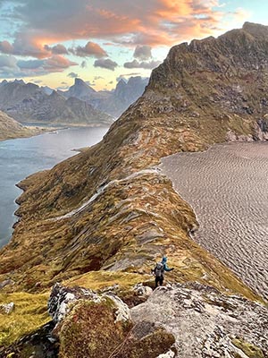 The ferry connection did not work for us. The next ferry that day meant waiting 2.5 hours and then only getting to Reine and waiting there til the next day to get the ferry to Kjerjfjorden. So we continued along from Vindstad walking up Bunesfjorden and over to the beach views of Buneset. This meant we had to hike up and over the pass at Helvetestinden, the views were amazing totally worth it. We attempted to get up to the summit however the gale force winds almost blew us off out feet and we decided to continue down into the valley to find camp before the light faded. Luckily the decent was sheltered from the highest winds. There was a very rough foot pad leading us down but we saw no cairns. The ground was slippery in places and very very steep, but we were able to zigzag down avoiding the dangerous rocky slabs. We have done a heap of this type of hiking before and we felt pretty comfortable slowly picking our was down the steepest sections with the aid of walking poles. If it had been raining/much wetter ground I think it might have been impassable. After searching for about half and hour we found some shelter for our tent behind a huge set of boulders about 500m from the village at Kjerkford. The majestic mountains and high cliffs here were so humbling.
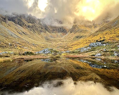
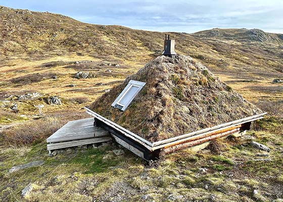
Day 4, Our fourth day (still Stage 9) took us up the stunning valley to lookout onto Horseid beach (we didn’t want to swim with high winds) and up and over the pass under Krokhammastinden. The walking seemed easier now than stages 11 and 10 apart from a bit of meandering around boulders along Fageravatnet and boggy ground close to Selfjordhytta. Before the main hut there was a lovely camping spot in a stand of pine trees with a wooden platform, fire pit and picnic bench. The nearby toilet hut was unusable though. We didn’t camp there because it was too early in the day and we didn’t have the key for the “DNT” hut. So we continued on the easy dirt road until we hit the trail again at Markvatnet. The lake is used for drinking water so camping near it is prohibited. We did find a wonderful emergency stone-built shelter with 2 wooden platforms that we used to camp in. That night we had the best view of the Aurora and had a dry (warmish) place to camp, it was the perfect size for two people. It was marked on the topo map.
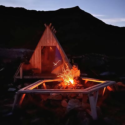 Day 5, our Stage 8 started the next day with a wonderful easy walk to the beach at Kvalvika. The tide was out and it made for even easier walking up to the view point at Ryten. This section was our least favourite because of the many many day walkers/other hikers we encountered. However we really enjoyed the fact that the wind had finally died down and the sun was shining. We dropped down to the road by lunchtime and tried to hitchhike along to the start of Skjelfjorden; unfortunately no-one stopped to help us. If we had have know we would have attempted to coordinate our road walking with a bus timetable. That day we had time up our sleeve to hike the side-trip up to Volandstinden. We left our bags at an emergency shelter called the grill house. When we returned to our bags it was sunset and so we made camp in the modern shelter (room for 3 people max). With no door it was a cool night but we enjoyed the outdoor fireplace making use of the grill over the fire for plenty of hot drinks.
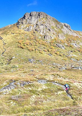
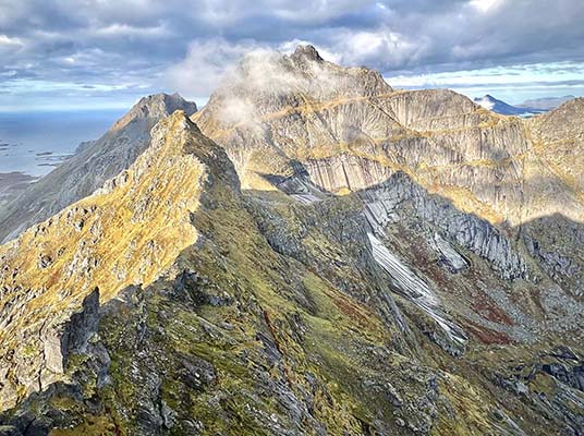
Day 6, we continued about 8 km along the road to the end of the headland at Vester Nesland. We saw only two cars, niether of which wanted to stop to give us a ride (no busses). However we did find some more fresh mussels to supplement our protein intake. After a hearty breakfast we decided to take the side-trip up to the top of Tonsasheia. This was our favourite side trip, the longest, and because we didn’t take the same route up/down, we had to carry heavy packs. The footpad lead us up a stream and a steep slope, the footpad disappeared a lot but we just headed in the right direction. Getting to the top of the saddle was the end of the steep section and we were able to contour round the ridge on the north side to get to the summit. It was made memorable by the swooping sea eagle and the fantastic views of the huge summit of Stjerntinden (only accessible with climbing equipment and skills). The decent down took a south-easterly route back towards Stage 7 and the ocean. We would highly recommend this route up and over (about 6.5 km total) unless the weather is bad. We found a flat dry camp near the coast but we had to collect stream water further up.
Day 7, we started Stage 6 at Nusfjord, a cute little fishing village, jetty, cafe and open air museum. The toilets for the museum reception were open (warm water/soap!) and free. We walked again along the road for about 2-3 kms without any hitchhiking luck and started along the clear path towards Napp. There were a few boggy sections but it was pretty easy going following the cairns. All afternoon we enjoyed the views across to the north and a new island of Vestvagoya. Once we got back to our vehicle we were able to drive it under the tunnel that has no pedestrian access and go to Leknes to resupply/shower etc.
Day 8, we decided not to set off until after lunch. We left the car in Leknes and walked out into Stage 5 going north again. The website mentions a rerouting due to an angry farmer, we followed the GPX route we downloaded from the website without any issues and encountered some other hikers/trail runners. Nearing nightfall we found a luxurious emergency shelter (run by the local hunting and fishing association) hidden at the side of Kringbotnsvatnet, it had blankets and mattresses, pure bliss that we didn’t have to tent it. Furthermore the Aurora was amazing for about 2 hours that night.
 Day 9, this day (Stage 4) was a long hike and we hit some patches of rain, but we still managed a shot side trip up to the top of Kartstaven. The paths here were numerous and many times we found ourselves on a different route to the suggested route. It was never too difficult to find ourselves back on track again but it must have happened 6-8 times in one day. When we got back to the road just north of the hamlet of Horn plan A was to try and hitch a ride back to Leknes (30 km) to move the vehicle once again.
Unfortunately after almost 2 hours without any luck we gave up and made camp near the ocean, unfortunately there was only brackish water around here so if you plan to camp near here make use you have collected plenty on the way down the mountain.
Day 10, in the morning we waited for the scheduled 7.16 am bus back to Leknes, which did not turn up. The next bus at 8.06 am arrived and we got back to the vehicle by 9 am. This was our biggest rest-day, enforced by the public transport timetable. We drove to the southern end of Stage 3 at Olderfjorden, left the vehicle there and caught the first of three buses at 2.16 pm to Delp, a journey that took about 2.5 hours by bus. We were thankful of the rest day and time spent on the bus as the rainy weather was the worst it had been on the trip so far. So for the first time we were walking in the southerly direction. We decided to camp on the high 400m plateau after the short sharp ascent up Delpen. Unfortunately we made the mistake of thinking we’d easily find a steam or small tarn before we hit camp. There was absolutely no water up there, apart from the odd muddy puddle and it had been raining all day.
Day 11, the weather was supposed to clear up by 10 am, but it stayed cloudy and drizzly until about noon. We had great views until about 650m elevation when we were in cloud. We were however quite keen to get down to the lake 4.5 km along from where we had camped so we didn’t linger long at the top of Matmora. After the tarn the downward path was easy going and in one section there was a rope to help people from slipping. When we got to the road we once again tried and failed to hitchhike for 4.5 km. At the turn off point at Midnattsolveien there was a large sign saying “Private road/No entry”. Looking at the map there did not seem to be any alternative so we headed down the track for about 1 km. There wasn’t anyone around but at the point where the private road was supposed to turn into the trail was a house with the lights on and lots of cars outside. Nervous that we were trespassing we rushed back down the track 50 m out of sight of the house and into the wooded section. We walked across a line of telegraph/electricity poles and we were able to easily navigate our way to the path marked on the map. We looked at the website to see if there had been any mention of a re-route around a private road but found nothing.
The boggy path up to the high lakes and hills south of Svolvear was very pretty and we saw no-one until we hit the sheltered eastern side of Botnvatnet where there was a noisy group of young adults. So we decided to push onwards to find a better spot to camp that night. With limited flat spots with shelter from the wind on the decent we carried on until the day light had just about faded (7.30 pm). We found a very good spot to camp beside Over Svolvearvatnet and the pipeline - the veranda of the locked Red Cross mountain hut. It rained almost all night and we felt great that we were dry and sheltered.
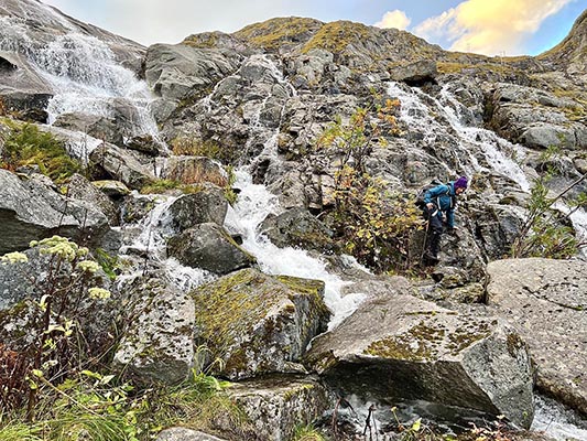
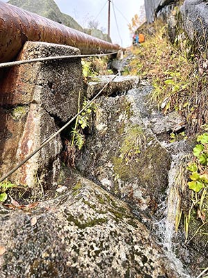 Day 12, the rain cleared by 10 am and we continued on to complete our final stage (Stage 3) of the whole crossing. The day started off easy going along new duck board, but when the track diverted from the duckboard along the shores of Nedre Svolvaervatnet passing infront of a private house we found the stream on the other side impassable after the recent rain. So we had to go off track towards a footbridge about 500m away (GPS 68.25391, 14.52556). Would recommend staying on the duckboard and following the track that loops around the house on the waters edge. Eventually we reached the upward trail through a beautiful old pine forest and hit the steep trail along the edge of another pipeline. There were ropes all the way up to aid the climb and due to the recent rain the track was basically a waterfall. We found the ascent fun but slow going. At the top we found another wonderfully luxurious little emergency shelter with gas, bunkbeds and a little kitchen. We stopped there for lunch and headed on feeling refreshed.
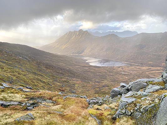
We ignored two obvious paths up Smitinden and Jordtinden (might have been good side-trip/alternative route options had the weather been better). Instead we followed the GPX route and took a bearing steeply up and over a saddle to the south west of Mingmaurtindan. We didn’t find a much of a track on the upward slope but when we got to the saddle there was a couple of rock cairns and a good footpad leading down to the valley below. The views across to the mountains and waters of Olderfjorden were amazing in the late afternoon light. The decent into the valley was slow going because it was so boggy and there was a high risk of falling over on the very muddy slope. We were again thankful of our walking poles and gaiters. There was another emergency shelter visible on the valley floor but when we got there it was locked. However a little further on, closer to the edge of the fjord we found an unlocked emergency shelter amongst the trees that would have made a nice place to camp. Walking about 250 m back up the river we found the footbridge to the southern edge of the fjord and then our last section of hiking was only about 90 minutes along flat ground. Some of the rocks were immensely slippery and we were thankful that the last third of the way was along a dirt road.
Other notes:
- Despite hiking at the end of summer we encountered many wild berries to eat (especially tasty nearer the sea). We saw sea urchins a plenty at times but did not have the know-how to harvest these.
- There were minimal mosquitoes and did not take any repellant.
- The website we used for the bus timetable was www.reisnordland.com (different to the broken link used on the rando-lofoten website). The timetable there seems to be updated live and if the bus was running late it would show the difference by a few minutes. We did ask the driver about the bus that didn’t turn up and they had no idea. All the buses were very nice - fitted with USB charging ports and toilets. The bus was 84NOK per person for one journey. The use of credit cards was preferred. Bus time tables vary between weekend/weekdays.
- We initially were thinking of not taking a vehicle over to the islands but we were glad we did in the end as it offered us a little respite from the trail. It allowed us to resupply easily after 7 days and helped us get across 2 of the major road sections.
- Drinking water was never a problem (apart from up Delpen/Matmora) we treated the water whenever there was evidence of sheep around (which was about 30% of the time).
- We asked at the DNT office in Bodo beforehand about huts and were advised that the DNT huts on the Lofoton islands are maintained by volunteers and therefore require a different key, we were advised it not a straightforward system and so we didn’t bother pursuing it. Had we encountered poorer weather conditions I think it would have been nice to have had the key/code but in the end we were ok because we found some free open emergency shelters.
- We bought the three recommended 1:50.000 topo maps as a back up incase the Gaia maps on our phones didn’t work. The paper tops maps were useful once or twice to check the location of the shelters that were not usually marked in Gaia.
- We had good mobile service the vast majority of the time.
- Our most valued bits of kit were our poles (one each), gaiters, waterproof socks and thermal layers.
- The temperatures were very manageable during the shoulder season, we only saw frost once. The camps we made at sea level were significantly warmer than any we had at elevation. The daylight faded slowly but as each day went by the sun set 8 minutes before the previous day.