


Go back
Moyenne, Mauvaise
After passing the village of Valberg, continue along road 815 northwards towards the hamlet of Nedredal. Take the tarmacked track to Nedredal on your left and climb to Øvredal. Park on the left, 200m from the end of the road near the dip where you will find a bridge that will take you across the river.
Start parking: N68° 12.705' E14° 02.133'
Sheep gate: N68° 12.735' E14° 01.586'
Summit: N68° 11.822' E14° 01.066'
Description
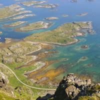
This hike, which offers no particular challenges, quickly takes you onto a magnificent path along a ridge from where you can see the most beautiful part of the eastern coast of the Lofoten Islands with its many coves of fine sand, its clusters of islands and islets and its crystal-clear waters.
More information about this hike...
|
|

Accessibility
Accessible to dogs, Family friendly, Snowshoe