Hiking to Keiservarden and Snøtinden

DifficultyMedium
LocationAustvågøya
Duration4 hrs
Distance9.58 km
Climb864 m
Maximum altitude646 m
Map - 1:50 000Vågan
Snow riskuntil may at the top
  • Type of hike : Go back
  • Visibility of the route : good, avreage to poor in some places
  • Start/Finish : Coming from Digermulen hamlet, follow the road in direction of Valen on 1,8km. Park on the small parking space on your right (sea side). The trail head start on the other side of the road just opposit to the parking place.
  • GPS Point : Start/Finish (parking) : N68° 18.253' E15° 00.638'
  • Note : Avoid the trail shown on the Nordeca map which start directly from Digermulen hamlet. This trail is very exposed to rock fall in some places!
Sommet de Keiservarden (îles Lofoten)
Description

Pictures and track proposed by Halfdan Holm

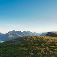
The trip up to Keiservarden (The Kaiser Cairn) is quick, but provides a stunning view of Raftsundet and some of the most alpine peaks in Norway. The viewpoint is named after Kaiser Wilhelm II who visited Digermulen, and this peak on several occations. The trip can be doubled in length to Snøtinden (The Snow Peak) providing a panoramic view over all the rugged peaks of eastern Lofoten.

Several maps show a trail going directly from Digermulen to Keiservarden. This route is however significantly exposed to rockfalls. Thus the trip starting about 1.5 km southeast of Digermulen will be described here. You will find the trailhead on the northern side of the road, just opposite a small parking lot. The trail starts out with an easy climb through the forest. After the turn to the left, you will have to pass some stretches of mud where you might get your feet wet. On the last stretch through the forest there are several points on the trail which can require a bit of scrambling. There are however ropes installed to help you keep your balance. At around 300m you break through the tree line. Here the trail can become somewhat faint, but if you follow the top of the ridge, you will soon see the two cairns marking the peak.

The trail up to Snøtinden continues along the ridge and down past a small lake and forest. After a small climb you see two more small lakes to the west, before ascending directly towards the summit. The trail continues around the southeast side of the peak before you reach the top. Same way back.

Accessibility
No
Yes
No

Join the start of the hike with Google Maps

You can use your actual location or enter the name of the place from which you wish to start

Other hikes nearby

Hiking to Geitgallien

Hiking to Geitgallien

Located at 12.0 km
Austvågøya
DifficultéDifficult
10 km

Accessibility
No
No
No
Hiking to Sautinden

Hiking to Sautinden

Located at 13.7 km
Austvågøya
DifficultéEasy / Medium
7.6 km

Accessibility
Yes
Yes
No
Hiking to Kvittinden

Hiking to Kvittinden

Located at 13.7 km
Austvågøya
DifficultéMedium
9.3 km

Accessibility
No
Yes
No
Hiking to Baken

Hiking to Baken

Located at 15.0 km
Austvågøya
DifficultéMedium / Difficult
10.6 km

Accessibility
No
No
No

Copyright

Any representation whether total or partial of this site or content (general structure, texts, sound, logos, images whether animated or otherwise), by any method whatsoever, without the authors express prior approval is prohibited and constitutes infringement sanctioned by the Intellectual Property Code. The GPX tracks that can be downloaded on this website, bellong to hiking-lofoten and is for a private use only (not for commercial use). In order to reproduce the tracks in any form or on any medium (paper, digital, website, etc.), we ask you to mention the following (under or on the map): GPX track © hiking-lofoten.net